
Податотека:Serbia ethnic 6 8 century-sr.png

Големина на овој преглед: 334 × 600 пиксели. Други разделности: 133 × 240 пиксели | 638 × 1.146 пиксели.
Изворна податотека (638 × 1.146 пиксели, големина: 66 КБ, MIME-тип: image/png)
| Ова е податотека од Ризницата на Викимедија и може да се користи на други проекти. Подолу е наведена содржината на нејзината описна страница.
|
Опис
| Опис |
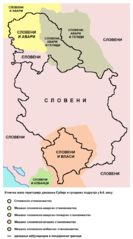
English: Ethnic map of the territory of present-day Serbia and neighbouring areas in the 6th-8th century (according to the historical atlas for schools, published in Belgrade in 1970). Српски / srpski: Етничка мапа територије данашње Србије и околних подручја у 6-8. веку (мапа је урађена према Школском историјском атласу, објављеном у Београду 1970. године). |
| Датум | |
| Извор | сопствено дело |
| Автор | PANONIAN |
Лиценцирање
Јас, праводржецот на ова дело, со ова го објавувам истото под следнава лиценца:
| Оваа податотека е достапна под лиценцата Криејтив комонс Универзално предавање во јавна сопственост. | |
| Лицето поврзано со делото со овој документ го има предадено истото во јавна сопственост, откажувајќи се од сите права на тоа дело за цел свет, под законот за авторско право и поврзани или сродни законски права што ги имало на тоа дело, дотолку колку што е дозволено со закон. Делата под CC0 не бараат припишување (наведување автор и/или извор). Кога го наведувате делото, наводот не треба да подразбира каква било поддршка од авторот.
|
References
Main reference:
- Created according to the historical map from this history atlas: "Školski istorijski atlas, Zavod za izdavanje udžbenika SR Srbije, Beograd, 1970."
Secondary references (with similar maps):
- The Times - Atlas Svjetske Povijesti, Dopunjeno izdanje za Jugoslaviju, Cankarjeva založba, Ljubljana, 1986. - this is Yugoslav (Serbo-Croatian) edition of this original source: The Times Atlas of World History, Times Books Limited, London, 1984. (in Yugoslav version from 1986 there is similar map on page number 298)
- Denis Šehić - Demir Šehić, Istorijski atlas Sveta, Beograd, 2007. (similar map is published on page number 29)
- The former Yugoslavia's diverse peoples: a reference sourcebook By Matjaž Klemenčič, Mitja Žagar: https://books.google.com/books?id=ORSMBFwjAKcC&pg=PA3&lpg=PA5&vq=maps&output=html (a source with similar map published on page number 3)
- Here is an external link with similar map: http://www.camo.ch/illiricum7.htm архивски примерок на Wayback Machine
Историја на податотеката
Стиснете на датум/време за да ја видите податотеката како изгледала тогаш.
| Датум/време | Минијатура | Димензии | Корисник | Коментар | |
|---|---|---|---|---|---|
| тековна | 21:45, 25 февруари 2014 | | 638 × 1.146 (66 КБ) | PANONIAN | {{Information |Description ={{en|1=Ethnic map of the territory of present-day Serbia and neighbouring areas in the 6th-8th century (according to the historical atlas for schools, published in Belgrade in 1970).}} |Source ={{own}} |Author... |
Употреба на податотеката
Податотекава се користи во следнава страница:
Глобална употреба на податотеката
Оваа податотека ја користат и следниве викија:
- Употреба на sr.wikipedia.org