Податотека:India Maharashtra locator map.svg
Содржината на страницата не е поддржана на други јазици.
Од Википедија — слободната енциклопедија

Изворна податотека(SVG податотека, номинално 1.574 × 1.738 пиксели, големина: 836 КБ)

Врска до Ризницата Ова е податотека од Ризницата на Викимедија и може да се користи на други проекти. Подолу е наведена содржината на нејзината описна страница.
Заедничката ризница е складиште на слободно-лиценцирани слики и снимки. И Вие можете да помогнете.
Наслов
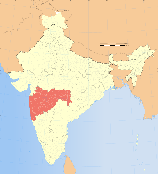
Maharashtra locator map
Опис
Locator map of the state of Maharashtra, India with district boundaries.
Толкување
Датум
Извор

сопствено дело
International Borders: University of Texas map library - India Political map 2001
Disputed Borders: University of Texas map library - China-India Borders - Eastern Sector 1988 & Western Sector 1988 - Kashmir Region 2004 - Kashmir Maps.
State and District boundaries: Census of India - 2001 Census State Maps - Survey of India Maps.
Other sources: US Army Map Service, Survey of India Map Explorer, Columbia University

Map specific sources: .
Творец
This Image was created by User:PlaneMad.
  • If you are using the image under the creative commons share alike license please credit the photo CC-by-sa PlaneMad/Wikimedia and include a link to this page. No explicit permission is needed from me, but id appreciate an email if my work has been of help to you.
  • If you dont want to release your work under a creative commons license, please mail me at arun.planemad@gmail.com or catch me at my Website to negotiate a custom license as per your needs.
Дозвола
(Повторно користење на податотекава)
Јас, праводржецот на ова дело, со ова го објавувам истото под следнава лиценца:
w:mk:Криејтив комонс
наведи извор сподели под исти услови
Можете:
  • да споделите – да го умножувате, распространувате и емитувате делото
  • да преработувате – да преработувате
Под следните услови:
  • наведи извор – Ќе мора да дадете прикладен припис, да ставите врска до лиценцата и да укажете дали има направено промени. Ова може да биде направено на било кој разумен начин, но без да оддава впечаток дека лиценцодавецот стои зад Вас и Вашата употреба.
  • сподели под исти услови – Ако го измените или преобразите делото, или пак ако основате друго дело на него, добиеното дело (придонесот) морате да го распространувате (објавувате) само под истата или складна лиценца на изворната.

The frontiers depicted on the Indian maps in Wikipedia are from a neutral point of view and may differ from official government maps of India, Pakistan and China. Please consult local laws governing publication of maps before usage.
 Геовременски податоци
Прикажано време втора половина на XX век и XXI век
Просторен појдовен систем conic
Рамка
36°42′N 64°48′E / 36.70°N 64.8°E / 36.70; 64.8 37°14′N 99°00′E / 37.23°N 99.0°E / 37.23; 99.0
5°54′N 68°46′E / 5.9°N 68.76°E / 5.9; 68.76 6°15′N 96°05′E / 6.25°N 96.09°E / 6.25; 96.09
Геонавод Ставете ѝ геонаводи на картата во Wikimaps Warper Ако е потребно, задајте warp_status = skip за да скриете.
 Архивски податоци
Белешки Part of WikiProject India Maps
Други верзии


Notes

Depiction of India's borders

  • The territorial boundaries of India are shown as per the actual ground situation in accordance with international practices followed by the United Nations ([1], [2]) and the National Geographic Society ([3], [4])
  • This map is meant to be for illustrative purpose only and is not authenticated by official government sources. Please check the list of sources and references used to create the map for a measure of accuracy and verifiability.
  • The usage of these maps in India, Pakistan and China are governed by different laws that restrict depictions of boundaries other than what is officially recognized by the state. Please check local laws and modify the map accordingly before use.

Explanation of disputed boundaries

  • Boundary of Indian claim : The territory India claims is legally theirs, but the claim is disputed by China and Pakistan.
  • Line of Control/Line of Conflict : The de facto administrative boundary recognised by the international community. This UN ceasefire line is considered as a temporary solution to an ongoing conflict since the departure of the British Raj.

Borders of disputed regions

The depicted extent of the former territory of the British Indian Empire, succeeded by Republic of India, may not be accepted by few countries as legal due to ongoing border disputes:

  • The northern Himalayan region of the disputed territory Indian-administered Kashmir is claimed by India including (Pakistan-administered Kashmir) and the Chinese-occupied territory of (Ladakh plateau). Since 1972, it is divided between all three countries. See also Line of Control and Line of Actual Control.
  • Siachen glacier (shown white) is an actively contested region between India and Pakistan. Since 1984, the region is under Indian control.
  • The northeastern territory of Arunachal Pradesh is almost entirely claimed by China as part of its Tibetan territory.
  • Minor areas of eastern Kashmir's Ladakh division, Himachal Pradesh and Uttarakhand on the Chinese frontier are claimed by China. These areas are under Indian control.
  • A small area of Uttarakhand adjoining the Nepal border along the Sarda river is disputed between the two countries.

For a detailed map of all disputed regions in South Asia, see Image:India disputed areas map.svg

Internal borders

The borders of the state of Meghalaya, Assam and Arunachal Pradesh are shown as interpreted from the North-Eastern Areas (Reorganisation) Act, 1971, but has yet to be verified.

Territorial waters

The limit of the territorial waters of India extends to twelve nautical miles measured from the appropriate baseline. See this for more information.

Описи

Опишете во еден ред што претставува податотекава

Предмети прикажани на податотекава

прикажува

Историја на податотеката

Стиснете на датум/време за да ја видите податотеката како изгледала тогаш.

Датум/времеМинијатураДимензииКорисникКоментар
тековна08:53, 29 декември 2008Минијатура на верзијата од 08:53, 29 декември 20081.574 × 1.738 (836 КБ)Planemad{{Information |Description= |Source= |Date= |Author= |Permission= |other_versions= }}
19:28, 6 август 2006Минијатура на верзијата од 19:28, 6 август 20061.639 × 1.852 (750 КБ)Planemad{{WikiProject_India_Maps |Title=Maharashtra locator map |Description=Locator map of the state of Maharashtra, India with district boundaries. |Source=. |Date=August 6 2006 |Author=w:user:Nichalpw:user:Planemad |Thumbdir=CHANGE }}

Нема страници што ја користат оваа податотека.

Глобална употреба на податотеката

Оваа податотека ја користат и следниве викија:

Погледајте ја останатата глобална употреба на податотекава.

Метаподатоци