Податотека:1730 C. Homann Map of Asia - Geographicus - Asiae-homann-1730.jpg

Содржината на страницата не е поддржана на други јазици.
Од Википедија — слободната енциклопедија

Изворна податотека(4.000 × 3.492 пиксели, големина: 5,26 МБ, MIME-тип: image/jpeg)

Врска до Ризницата Ова е податотека од Ризницата на Викимедија и може да се користи на други проекти. Подолу е наведена содржината на нејзината описна страница.
Заедничката ризница е складиште на слободно-лиценцирани слики и снимки. И Вие можете да помогнете.

Опис

Johann Christoph Homann: Recentissima Asiae Delineatio : Qua Imperia, eius Regna, et Status, Unacum novissimis Russorum detectionibus circa Mare Caspium et Terram Yedso alias dict. per illor. Expedit. et Excursiones, factis sistuntur.   (Wikidata search (Cirrus search) Wikidata query (SPARQL)  Create new Wikidata item based on this file)
Уметник
Johann Christoph Homann  (1703–1730)  wikidata:Q18508380
 
Опис германски лекар, издавач и картограф
Датум на раѓање/смрт 1703 Уредете го ова на Википодатоците 1730 Уредете го ова на Википодатоците
Место на раѓање/смрт Нирнберг Нирнберг
Место на дејност
Нормативна контрола
artist QS:P170,Q18508380
Наслов
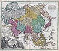
Recentissima Asiae Delineatio : Qua Imperia, eius Regna, et Status, Unacum novissimis Russorum detectionibus circa Mare Caspium et Terram Yedso alias dict. per illor. Expedit. et Excursiones, factis sistuntur.
Опис
English: A rare and attractive 18th century map of Asia by German map publisher Johann Christoph Homann. Covers the entire continent of Asia as well as parts of Europe and northeastern Africa. This is essentially a revised and updated version of J. B. Homann’s 1712 map of Asia. Features some interesting and important updates. Most notably, we see the addition of the Kamchatka Peninsula in the upper right hand quadrant. The lower part of the peninsula is labeled “Kurilorum Regio”, no doubt an early reference to the Kuril Islands. While Hokkaido is not present, Japan itself is separated from the mainland by a small archipelago. Just east of these islands we see the Canal de Piecko, and beyond that a large and curious land mass labeled Compagnie Land. Compagnie Land is a mythical landmass that can be traced the work of an unknown Spanish pilot who supposedly traveled from China to New Span and published his finding along with the works of Thevenot. Present in both the 1712 map and this one, Compagnie’s Land could possibly be an early representation of Alaska or a misrepresentation of Hokkaido. Korea or Corea is present if misshapen in roughly the correct location. Further south New Guinea, New Britannia, Australia (New Holland), Hoch Land, and Carpentaria (part of Australia) are personated in tentative form with largely unexplored boundaries. At the center of the map the Caspian Sea is displayed according to the 1722 surveys of Karl van Verden. Bottom left quadrant features a decorative title cartouche displaying an enthroned king in Middle Eastern or Indian garb, exotic animals including a lion and leopard, trade goods, Camels, and bowing supplicants. A spectacular and important 18th century map of Asia.
Датум ~ 1730
date QS:P571,+1730-00-00T00:00:00Z/9,P1480,Q5727902
(undated)
Димензии висина: 19,5 инчи (49,5 см); ширина: 22,5 инчи (57,1 см)
dimensions QS:P2048,19.5U218593
dimensions QS:P2049,22.5U218593
Пописен бр.
Geographicus link: Asiae-homann-1730
Извор/Фотограф
Дозвола
(Повторно користење на податотекава)
Дводимензионалното уметничко дело представено на оваа слика е во јавна сопственост во целиот свет во согласност со смртта на авторот или датумот на издавање.
Public domain

Ова дело е во јавна сопственост и во земјите и подрачјата каде авторските права важат додека е жив авторот плус 100 години или пократко.


Ќе мора да ставите и ознака за јавна сопственост во САД за да укажете дека делото го има укажаниот статус во таа земја.
Поради тоа, оваа репродукција на делото исто така е во јавна сопственост. Ова се однесува на репродукцијата направена во САД (погл. Bridgeman Art Library v. Corel Corp.), во Германија, како и во многу други земји.

Описи

Опишете во еден ред што претставува податотекава
A rare and attractive 18th century map of Asia by German map publisher Johann Christoph Homann.

Предмети прикажани на податотекава

прикажува

50d7f41d7c194c9d50a804aaa1b6cba16d8c371b

3.492 пиксел

4.000 пиксел

Историја на податотеката

Стиснете на датум/време за да ја видите податотеката како изгледала тогаш.

Датум/времеМинијатураДимензииКорисникКоментар
тековна18:35, 16 март 2011Минијатура на верзијата од 18:35, 16 март 20114.000 × 3.492 (5,26 МБ)BotMultichill{{subst:User:Multichill/Geographicus |link=http://www.geographicus.com/P/AntiqueMap/Asiae-homann-1730 |product_name=1730 C. Homann Map of Asia |map_title=Recentissima Asiae Delineatio : Qua Imperia, eius Regna, et Status, Unacum novissimis Russorum detect

Податотекава се користи во следнава страница:

Глобална употреба на податотеката

Оваа податотека ја користат и следниве викија: