
Податотека:Swisstopo Dufourkarte BLATT XVI GENEVE LAUSANNE LT TK 016 1845.tiff

Изворна податотека (11.983 × 8.600 пиксели, големина: 98,3 МБ, MIME-тип: image/tiff)
| Ова е податотека од Ризницата на Викимедија и може да се користи на други проекти. Подолу е наведена содржината на нејзината описна страница.
|
Опис
| Предупредување | Изворната слика има многу пиксели, поради што нема да се вчита, или ќе ви го закочи прелистувачот. |
|---|
| Наслов |
Deutsch: Blatt XVI. Genève, Lausanne der Topographischen Karte der Schweiz, LT TK 016 1845 |
|||||||||||||||||||||||
| Опис |
English: Sheet XVI. Genève, Lausanne of Topographische Karte der Schweiz (Dufour Map).
Deutsch: Blatt XVI. Genève, Lausanne der Topographischen Karte der Schweiz, auch Dufourkarte genannt. Dieses älteste amtliche Kartenwerk der Schweiz wurde unter der Leitung von Guillaume Henri Dufour erstellt.
Français : Feuille XVI. Genève, Lausanne de la Carte Dufour. |
|||||||||||||||||||||||
| Толкување |
Deutsch: Zeichen und Abkürzungen |
|||||||||||||||||||||||
| Adjacent sheets |
|
|||||||||||||||||||||||
| Sheet index | index map, gallery | |||||||||||||||||||||||
| Извор |
|
|||||||||||||||||||||||
| Творец | ||||||||||||||||||||||||
| Дозвола (Повторно користење на податотекава) |
|
|||||||||||||||||||||||
| Геовременски податоци | ||||||||||||||||||||||||
| Прикажано време | ||||||||||||||||||||||||
| Местоположба на картата | Genève, Lausanne | |||||||||||||||||||||||
| Просторен појдовен систем | Bonne'sche Projektion | |||||||||||||||||||||||
| Размер | 1:100.000 | |||||||||||||||||||||||
| Насока |
 |
|||||||||||||||||||||||
| Геонавод | Ако е потребно, задајте warp_status = skip за да скриете. | |||||||||||||||||||||||
| Библиографски податоци | ||||||||||||||||||||||||
| Серија | Erstausgabe Topographische Karte der Schweiz | |||||||||||||||||||||||
| Лист од картата | 16 | |||||||||||||||||||||||
| Јазик | германски | |||||||||||||||||||||||
| Издавач | ||||||||||||||||||||||||
| Архивски податоци | ||||||||||||||||||||||||
| Збирка |
Bundesamt für Landestopografie swisstopo, Kartensammlung
|
|||||||||||||||||||||||
| Пописен бр. |
LT TK 016 1845 |
|||||||||||||||||||||||
| Димензии | висина: 61 см; ширина: 83 см | |||||||||||||||||||||||

Лиценцирање
The data made publicly available by swisstopo may be used, distributed and made accessible. Furthermore, they may be enriched and processed and also used commercially. A reference to the source is mandatory. In the case of digital or analogue representations and publications, as well as in the case of dissemination, one of the following source references must be attached in any case:
Terms of use for free geodata and geoservices (OGD) from swisstopo
|
.svg) |
Историја на податотеката
Стиснете на датум/време за да ја видите податотеката како изгледала тогаш.
| Датум/време | Минијатура | Димензии | Корисник | Коментар | |
|---|---|---|---|---|---|
| тековна | 09:46, 14 јуни 2023 | 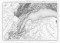 | 11.983 × 8.600 (98,3 МБ) | Swisstopo historic | {{Map |title=Blatt XVI. Genève, Lausanne der Topographischen Karte der Schweiz, LK TK 016 1845 |description=Blatt XVI. Genève, Lausanne der Topographischen Karte der Schweiz, auch Dufourkarte genannt. Dieses älteste amtliche Kartenwerk der Schweiz wurde unter der Leitung von Guillaume Henri Dufour erstellt. {{Cultural property of regional significance in Switzerland|996}} |author=Guillaume-Henri Dufour; Rinaldo Bressanini; Heinrich Müllhaupt; [[Eidgenössisches Topographisches Bure... |
Употреба на податотеката
Податотекава се користи во следнава страница:
Глобална употреба на податотеката
Оваа податотека ја користат и следниве викија:
- Употреба на de.wikipedia.org
- Употреба на hr.wikipedia.org