
Податотека:Teideform2.png

Големина на овој преглед: 504 × 600 пиксели. Други разделности: 202 × 240 пиксели | 588 × 700 пиксели.
Изворна податотека (588 × 700 пиксели, големина: 58 КБ, MIME-тип: image/png)
| Ова е податотека од Ризницата на Викимедија и може да се користи на други проекти. Подолу е наведена содржината на нејзината описна страница.
|
Опис
| Опис |
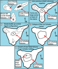
English: This is a very schematic diagram of the formation of the island of Tenerife and evolution of the current Teide volcano. In step one the island began as three separate shield volcanoes - Anaga to the NE, Teno to the NW and Roque del Conde to the south. Step Two: After a period of erosion of the older massifs a new period of volcanic activity saw the creation of the large Las Canadas volcano. Step Three: The islands current shape begins to become apparent as Las Canadas grew. Step Four: The Las Canadas edifice collapsed to form the Las Canadas Caldera into which Step Five: The current Teide/Vierjo Central complex has grown within this collapsed Las Canadas Caldera (more detailed/smaller of two versions). |
| Датум | 09/10/07 |
| Извор | сопствено дело |
| Автор | Fossiliferous |
Лиценцирање
Јас, праводржецот на ова дело, со ова го објавувам истото под следниве лиценци:

|
Се дава дозвола за умножување, распространување и/или менување на овој документ под условите на ГНУ-овата лиценца за слободна документација, само Верзија 1.2 или било која понова верзија објавена од Фондацијата за слободна програмска опрема; без неменливи делови и без текстови на предни и задни корици. Примерок од лиценцата ќе најдете во делот наречен ГНУ-ова лиценца за слободна докуменација. |
Оваа податотека е под лиценцата Криејтив комонс Наведи извор 3.0 Нелокализирана.
- Можете:
- да споделите – да го умножувате, распространувате и емитувате делото
- да преработувате – да преработувате
- Под следните услови:
- наведи извор – Ќе мора да дадете прикладен припис, да ставите врска до лиценцата и да укажете дали има направено промени. Ова може да биде направено на било кој разумен начин, но без да оддава впечаток дека лиценцодавецот стои зад Вас и Вашата употреба.
Одберете лиценца по ваш избор.
Историја на податотеката
Стиснете на датум/време за да ја видите податотеката како изгледала тогаш.
| Датум/време | Минијатура | Димензии | Корисник | Коментар | |
|---|---|---|---|---|---|
| тековна | 11:01, 1 февруари 2008 | | 588 × 700 (58 КБ) | Xiong Chiamiov | optimized using optipng |
| 16:18, 9 октомври 2007 |  | 588 × 700 (96 КБ) | ExtraFossiliferous | This is a very schematic diagram of the formation of the island of Tenerife and evolution of the current Teide volcano. In step one the island began as three separate shield volcanoes - Anaga to the NE, Teno to the NW and Roque del Conde to the south. Ste | |
| 16:12, 9 октомври 2007 |  | 588 × 700 (96 КБ) | ExtraFossiliferous | {{Information |Description=This is a very schematic diagram of the formation of the island of Tenerife and evolution of the current Teide volcano. In step one the island began as three separate shield volcanoes - Anaga to the NE, Teno to the NW and Roque |
Употреба на податотеката
Податотекава се користи во следнава страница:
Глобална употреба на податотеката
Оваа податотека ја користат и следниве викија: