
Податотека:Star trails over the Paranal Residencia, Chile.jpg

Изворна податотека (4.000 × 2.667 пиксели, големина: 11,01 МБ, MIME-тип: image/jpeg)
| Ова е податотека од Ризницата на Викимедија и може да се користи на други проекти. Подолу е наведена содржината на нејзината описна страница.
|
Опис
| Опис |
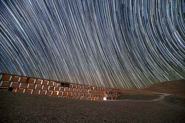
English: This image shows a dark Chilean sky filled with spectacular star trails — caused by the Earth's rotation during the camera's long exposure time. Underneath these dramatic streaks lies the Paranal Residencia, an oasis to the staff and visitors to ESO's Very Large Telescope, located high on Cerro Paranal in the Chilean desert.
Construction of the Residencia began in 1998 and was completed by 2002. Since then, it has offered a welcome break from the harsh, dry climate of the desert to the scientists and engineers who work at Paranal Observatory. The four-storey building has the majority of its structure buried underground. The facility was designed by German architects Auer+Weber to complement the surrounding environment. From certain angles, the combination of hi-tech utilitarian architecture and inconspicuous, almost camouflage-like design is reminiscent of a villain’s secret lair. Perhaps it is no surprise that the Residencia was selected as the setting for the final battle in the 2008 James Bond movie Quantum of Solace. Flickr user John Colosimo submitted this photograph to the Your ESO Pictures Flickr group. The Flickr group is regularly reviewed and the best photos are selected to be featured in our popular Picture of the Week series, or in our gallery. |
| Датум | |
| Извор | http://www.eso.org/public/images/potw1340a/ |
| Автор | John Colosimo (colosimophotography.com)/ESO |
| Местопол. на апаратот | | Оваа и други слики и нивните местоположби на: OpenStreetMap |
|---|
Лиценцирање
This media was created by the European Southern Observatory (ESO).
Their website states: "Unless specifically noted, the images, videos, and music distributed on the public ESO website, along with the texts of press releases, announcements, pictures of the week, blog posts and captions, are licensed under a Creative Commons Attribution 4.0 International License, and may on a non-exclusive basis be reproduced without fee provided the credit is clear and visible." To the uploader: You must provide a link (URL) to the original file and the authorship information if available. | |
Оваа податотека е под лиценцата Криејтив комонс Наведи извор 4.0 Меѓународна.
| |
Историја на податотеката
Стиснете на датум/време за да ја видите податотеката како изгледала тогаш.
| Датум/време | Минијатура | Димензии | Корисник | Коментар | |
|---|---|---|---|---|---|
| тековна | 04:43, 8 октомври 2013 | | 4.000 × 2.667 (11,01 МБ) | Jmencisom | User created page with UploadWizard |
Употреба на податотеката
Податотекава се користи во следнава страница:
Глобална употреба на податотеката
Оваа податотека ја користат и следниве викија: