
Податотека:Divalia Fossa IOTD-260.jpg

Изворна податотека (2.700 × 1.600 пиксели, големина: 739 КБ, MIME-тип: image/jpeg)
| Ова е податотека од Ризницата на Викимедија и може да се користи на други проекти. Подолу е наведена содржината на нејзината описна страница.
|
Опис
| Опис |
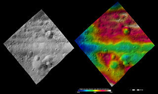
English: Divalia Fossa on 4 Vesta.
Original caption: Apparent brightness and topography images of Divalia Fossa and Rubria and Occia craters The left-hand image is a Dawn FC (framing camera) image, which shows the apparent brightness of Vesta’s surface. The right-hand image is based on this apparent brightness image, which has had a color-coded height representation of the topography overlain onto it. The topography is calculated from a set of images that were observed from different viewing directions, which allows stereo reconstruction. The various colors correspond to the height of the area. The white and red areas in the topography image are the highest areas and the blue areas are the lowest areas. These images show a part of the large trough, Divalia Fossa, which encircles most of Vesta’s equator. Divalia Fossa is visible in both the apparent brightness image and the topography image: it is the approximately 10 kilometer (6 mile) wide depression that runs from the left corner to the right corner of the images. The top rim of Divalia Fossa is especially clear in the topography image. A number of smaller troughs above and below Divalia Fossa are parallel to it. Rubria and Occia craters straddle Divalia Fossa: Rubria is the crater with dark and bright material above Divalia Fossa and Occia is the crater with bright and dark material below. These images are located in Vesta’s Gegania quadrangle, just south of Vesta’s equator. NASA’s Dawn spacecraft obtained the apparent brightness image with its framing camera on Oct. 16, 2011. This image was taken through the camera’s clear filter. The distance to the surface of Vesta is 700 kilometers (435 miles) and the image has a resolution of about 70 meters (230 feet) per pixel. This image was acquired during the HAMO (high-altitude mapping orbit) phase of the mission. These images are lambert-azimuthalmap projected. |
| Датум | |
| Извор | http://dawn.jpl.nasa.gov/multimedia/imageoftheday/image.asp?date=20120711 |
| Автор | NASA/ JPL |
Лиценцирање
| Оваа податотека е во јавна сопственост бидејќи нејзин создавач е НАСА. Правилата за авторски права на НАСА велат: „Материјалот на НАСА не е заштитен со авторски права освен ако не е поинаку нагласено“. (Правилата за авторски дела на НАСА или правила за користење на слики од Лабораторијата за реактивен погон (JPL)). | ||
 |
Предупредувања:
|
Изворна евиденција за подигањето
| Датум/време | Димензии | Корисник | Коментар |
|---|---|---|---|
| 2012-09-15 09:46 | 2700×1600× (756667 bytes) | Kwamikagami | Uploading a public-domain item using [[Wikipedia:File_Upload_Wizard|File Upload Wizard]] |

|
Категориите за оваа слика треба да се проверат. Проверете ги!
|
Историја на податотеката
Стиснете на датум/време за да ја видите податотеката како изгледала тогаш.
| Датум/време | Минијатура | Димензии | Корисник | Коментар | |
|---|---|---|---|---|---|
| тековна | 13:02, 25 ноември 2015 | | 2.700 × 1.600 (739 КБ) | PlanetUser | Transferred from en.wikipedia |
Употреба на податотеката
Податотекава се користи во следнава страница:
Глобална употреба на податотеката
Оваа податотека ја користат и следниве викија:
- Употреба на de.wikipedia.org
- Употреба на en.wikipedia.org
- Употреба на en.wikiversity.org
- Употреба на ro.wikipedia.org
- Употреба на ru.wikipedia.org
- Употреба на uk.wikipedia.org
- Употреба на zh.wikipedia.org